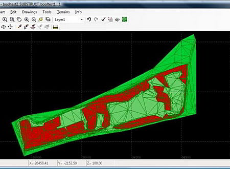
FastTerrain screenshot
SOFTWARE :FastTerrain
DEVELOPER :Diolkos3D
VERSION :3.0
PLATFORM :Windows
FILE SIZE :28.67 MB
LICENSE :Trial
DOWNLOADS :UserDownloads:1049
Program Description

In FastTerrain you are able to create, edit and visualize in 3D space digital terrain models. The program includes functionalities for break-lines and holes insertion as well as volume calculations and contours lines creation. With FastTerrain you can estimate excavation volumes by using digital terrain models (DTMs). Perfect choice for Civil Engineers, Surveyors, Architects in every day practice.

Features

  • Terrain model and contours creation.
  • Subtract terrain models and measure the volumes of fills and cuts between them (professional version).
  • Create excavation plan by using a single foundation poly-line (professional version).
  • Optimize terrain models created from contour lines by removing all flat triangles (professional version).

FastTerrain includes a flexible survey data reading interface that allows you to import ascii files exported from other survey software or equipment. Entities can be inserted also from DXF files or directly from AutoCAD via ActiveX technology. The output drawings are exported in DXF files or directly in AutoCAD. FastTerrain is an integrated solution designed for windows XP, Vista, 7.

* FastTerrain download link provides trial version of the software.

Similar Software
AEC Terrain Version:1.0 · AEC Logic
AEC Terrain

Create Digital Elevation Model from AutoCAD

AEC Terrain is designed to simplify terrain management and 3D-modeling.

usBIM.viewer+ Version:BIM 2(b) · ACCA Software
usBIM.viewer+

View and Edit BIM Models in the IFC Standard

usBIM. viewer+ gives you the possibility to view, convert and edit IFC files in a single software certified by buildingSMART International and completely free.

Terrain Tools 3D Version:9.0 · Softree
Terrain Tools 3D

Surveying, Mapping and Terrain Modeling

Terrain Tools 3D is a software toolkit for mapping, terrain modelling and land development.

CityWater Version:2021 · Aquaveo
CityWater

Visualize, Reference, Analyze Water Distribution Networks

Online web application for visualizing, referencing, and analyzing water distribution models.

EnCPT Version:1.3 · Ensoft
EnCPT

Import, Process, & Visualize Cone Penetration Test Data

Process raw CPT data, generating and exporting soil layering and properties to LPILE.

Comments & Reviews

No comments yet. Be the first to comment.

Submit a review about FastTerrain software with your social media profile

avatar
Rate This Software

FastTerrain has been rated 3.3 out of 5 points. A total of 3 votes cast and no one has reviewed the software yet.

Popular Programs

14966 hitsPOLEFDN 2.3

POLEFDN is a spreadsheet program written in MS-Excel for the purpose of analysis of a pole foundation assuming the use of a rigid round pier which is assumed free at the top and subjected to lateral and vertical loads.

8329 hitsAllPile 7.19

AllPile is a Windows-based analysis program that handles virtually all types of piles, including steel pipes, H-piles, pre-cast concrete piles, auger-cast piles, drilled shafts, timber piles, jetted piles, tapered piles, piers with bell, micropiles (minipiles), uplift anchors, uplift plate, and shallow foundations.

7991 hitsDips 8.0

Dips is designed for the interactive analysis of orientation based geological data.

7709 hitsSlide 9.0

Slide is the most comprehensive slope stability analysis software available, complete with finite element groundwater seepage analysis, rapid drawdown, sensitivity and probabilistic analysis and support design.

New & Updated

14 JanRetainX 2022

Free retaining wall design software that fully works in a web browser. Create a stable retaining wall design using state-of-the-art software without downloading software.

13 JanDartis SPT Correlations 1.1.0

Dartis SPT is a powerful, user-friendly software for correlating soil properties from SPT blow counts. We have gone through many papers and geotechnical reference books and collected over 200 SPT correlations with various soil properties.

25 NovGaeaSynergy 4.0

GaeaSynergy is an application suite for geoscientific analyses, mapping, data display and data management. The program can be used to evaluate contaminants, soil and rock properties, mineral deposits, and oil and gas deposits.

18 NovWinLog 4.0

The WinLoG extension module of GaeaSynergy can be used to quickly and easily create, edit and print boring logs, borehole logs and well logs for a variety of industries.